Category: Ride Routes

Information on places to ride your bike with route information (typically GPS and map), towns passed through, points of interest along the way, and maybe even photos

San Sebastian Teitipac

Bike rides to villages in the Tlacolula Valley to the east of Oaxaca City are generally easy affairs. The terrain is mainly flat, and there is a good network of dirt roads linking the many small communities. It is a simple matter to use the bike path on the old Ferrocarril to get from the center of Oaxaca out to Tule, which then serves as a springboard to other destinations.

The track illustrated below shows the route from my home in San Felipe del Agua to the village of San Sebastian Teitipac. The total distance is 44 miles (70.8 km), with an elevation gain & loss of 1498 feet (456.6 meters). The elevation chart below shows only the track for the return trip; you have to imagine the missing mirror image for the outgoing segment. If you elect to use the Zocalo as the start / end point rather than San Felipe, you can deduct 7 miles and 750 feet in elevation from the figures above.

San Pablo Etla Mountain Park – Loop 1

There are many trails in the communal park lands in San Pablo Etla that cry out to be ridden by mountain bikers. Shown below is a track utilizing a couple of these trails to form a loop. This loop ride is rated moderately difficult, both in terms of physical and technical challenges. It will give you a good workout and sharpen your bike handling skills. The ride is 12.4 miles (20 km) long and features an elevation gain / loss of 3370 feet (1027 meters). It is rated “Moderate to Difficult” because of its physical and technical demands.

The start / end point is the home of Carl Silverberg, a gringo who lived in the area for many years and worked hard to build this and other nearby trails. Sadly, Carl moved back to the U.S. in 2015. We miss his leadership and enthusiasm for mountain biking.

There is a user fee to access the park lands, which can be paid at the visitor’s center in the park.

Rojas de Cuahutemoc

Visitors to Oaxaca who are looking to explore the area by bicycle may very well enjoy an easy ride into the countryside to get a sense of the rural communities that dot the Valles Centrales.  Bikes can be rented from Zona Bici (Garcia Vigil 406-1 / www.zonabici.com.mx) or Bicicletas Pedro Martinez ( Aldama 418 / www.bicicletaspedromartinez.com) for a reasonable rate, and are perfect for a day’s outing.

Once out in the Tlacolula Valley, there are miles of dirt roads that can take the rider as far as he or she cares to go, with a minimum of climbing and no technical challenges.

The route shown below covers a distance of 23.1 miles (37.2 km), with an elevation gain & loss of 1185 feet (361 meters).  It can be shortened by 7 miles (and the elevation gain & loss reduced by 750 feet) by riding from the Zocalo rather than from San Felipe.

Loop Ride: San Felipe / San Bartolo Coyotepec / Zaachila / Cuilapam / San Felipe

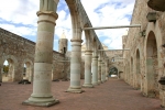
This is a great loop ride through open countryside with very little elevation change. San Bartolo Coyotepec is the village famous for shiny black, intricately incised pottery. There is a very good public gallery there featuring work from regional artisans who are expert craftsman working in ceramic, wood, metal, paint and other mediums. Zaachila is a very ancient, yet thriving community. The Zapotec ruins in the center of town are worth a visit, as is the weekly market on Thursdays. Cuilapam is historically one of the Mixtec villages on the outskirts of Oaxaca city, and features ruins of a never-finished Dominican convent.

The route takes you on city streets through Oaxaca, then along a principal highway to San Bartolo, where you jog to the west on a little-used but well-paved road to Zaachila. From Zaachila you can either follow the track shown below, which meanders on footpaths and backcountry dirt roads, or opt for the (shorter)  paved highway to Cuilapam. The final segment from Cuilapam back to Oaxaca is along a busy stretch of road. It is best to do this ride on a Sunday, when traffic is just a fraction of what it is other days of the week.

I neglected to turn on my GPS unit until I was in downtown Oaxaca, so the elevation plot below is missing the initial 375 foot descent from San Felipe into town — not a problem if you begin and end your ride at the Zocalo.

The entire loop covers about 32 miles (51.5 km), and there is an elevation loss & gain of about 1425 feet (434 meters) along the way. If you elect to do this ride, but use the Zocalo instead of San Felipe as the start / end point, the distance will be 7 miles shorter and the elevation gain / loss will be 750 feet less.


Teotitlan del Valle

The village of Teotitlan del Valle is famous as the home of some of the best weavers in Oaxaca state. It is also one of the oldest continuously inhabited towns in the world — people have lived there for about 9000 years, putting it in the same category as Damascus and towns in the Fertile Crescent in Persia. It is situated on the north side of the Tlacolula Valley not many miles east of Oaxaca city. A bike ride there on a pretty day can be most enjoyable!

The track on the map below shows the route we followed one Sunday, riding out-and-back from the Krotalus Bike shop (Calle Sabinos 309-B in Colonia Reforma / www.krotalusmtb.com.mx). Bernardo, the store manager, showed me the route he likes to follow on this ride, which stays away from busy streets and the main highway and uses bike paths and country back roads, instead.

We covered 34.6 miles (55.7 km) on this ride, and recorded an elevation gain of 1121 feet (342 meters), most of that in the final leg getting to Teotitlan. Riding at a moderate pace – and stopping for lunch in Teotitlan – we finished the ride in a bit over four hours.

%d bloggers like this: